Added to your Itinerary Planner below
Distance calculator
Map Filters
Customise your trip with our filters.
Map Filters

Toggle between the options below to show available markers.
General info Equestrian Info Cycling InfoAccommodation
Points of interest
Services
Routes
Accommodation
Points of interest
Transport
Accommodation
Points of interest
Transport


The custom route elevation is created when you use the distance calculator (above) to draw a line.
The custom route elevation is created when you use the distance calculator to draw a line.

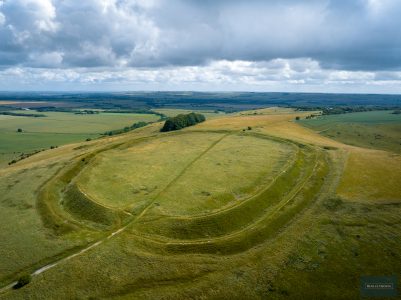
Visit this striking Iron Age hill fort offering far-reaching views over the surrounding countryside.
Marvel at the scale of the double ditch and enjoy wildflowers across the unimproved chalk grassland. This was the site of a battle where Cynric defeated the Britons in 556AD.
There is a large car park, picnic benches and toilets. The country park is managed by Swindon Borough Council.
Discover more about Barbury Castle through the Ridgeway Top 50 Hillforts, Wartime, Famous Archaeologists, Chalk Flowers, Butterflies and Viewpoints and Views.

