Added to your Itinerary Planner below
Distance calculator
Map Filters
Customise your trip with our filters.
Map Filters

Toggle between the options below to show available markers.
General info Equestrian Info Cycling InfoAccommodation
Points of interest
Services
Routes
Accommodation
Points of interest
Transport
Accommodation
Points of interest
Transport


The custom route elevation is created when you use the distance calculator (above) to draw a line.
The custom route elevation is created when you use the distance calculator to draw a line.

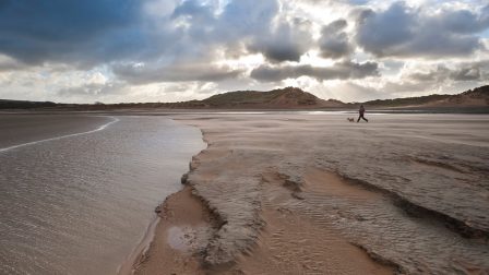
Sandy estuary of the River Duddon with panoramic of the Lakeland mountains. All the dune grasslands at Sandscale Haws support a rich flora including the very rare Dune Helleborine. A significant area for Natterjack Toads, Sandscale Haws supports one fifth of the national population of the rare amphibian, which is only found at a few other sites in the UK. There are also migratory bird populations of international importance, including Pintail, Red Knot and Common Redshank. Over 20,000 wintering waterfowl can be seen regularly.