Added to your Itinerary Planner below
Distance calculator
Map Filters
Customise your trip with our filters.
Map Filters

Toggle between the options below to show available markers.
General info Equestrian Info Cycling InfoAccommodation
Points of interest
Services
Routes
Accommodation
Points of interest
Transport
Accommodation
Points of interest
Transport


The custom route elevation is created when you use the distance calculator (above) to draw a line.
The custom route elevation is created when you use the distance calculator to draw a line.

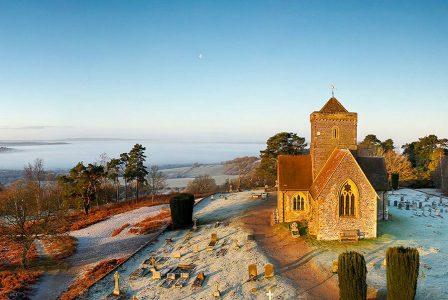
The beautiful St Martha’s Church (also known as St Martha-on-the-Hill) is a listed grade II Historic building. Perched on the top of the hill on the North Downs Way National Trail, the building is accessible only by foot.
The sandy hillside is clothed in woodland and part of the 60 hectare site has a rare mixture of chalk grassland plant species and is designated a Site of Special Scientific Interest (SSSI). There is also an area called The Arboretum where, in 1900, the owners of the Albury estate planted exotic cedars, spruces and other softwood trees.