King Charles III England Coast Path – East Anglia
From the Wash to Tilbury on the Thames Estuary, passing stunning wildlife and culture. Explore the sand dunes, market towns and villages all adjacent to stunning seascapes.

From the Wash to Tilbury on the Thames Estuary, passing stunning wildlife and culture. Explore the sand dunes, market towns and villages all adjacent to stunning seascapes.
The East Anglia coast is renown for its long sandy beaches and fabulous wildlife habitats, but there is so much more to enjoy. Watch the cruise ships at Tilbury docks or the ferries at Felixstowe, look for a beach made entirely of rounded glass, search for elephant fossils at West Runton, eat crab at Cromer, admire the red and white striped cliffs at Hunstanton and visit the lively seaside resorts of Southend-on-Sea, Clacton-on-Sea, Southwold (make sure you check out the pier) and Great Yarmouth.
Not all of the Tilbury to Harwich stretch of the King Charles III England Coast Path is open. The trail is open from Tilbury on the Thames estuary north past Canvey Island, Southend-on-Sea and Maldon. The open section ends at Salcott, close to West Mersea. Work is underway to open the remaining part.
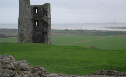
The Tilbury to Southend section is well served by public transport allowing for linear or circular walks on the coast or around islands. Starting with views of the ships at Tilbury Cruise Terminal and then the tall cranes of the DP World London Gateway Port it soon takes you out to see ancient forts protecting the Isle, crop filled fields and low-lying salt marshes. You can visit the point where SS Empire Windrush docked; where Queen Elizabeth made her rousing speech to troops at Tilbury Camp; visit the World’s End Pub frequented (according to his diaries) by Samuel Pepys; or the forts of Tilbury and Coalhouse and the 13th Century Hadleigh Castle. The London 2012 Olympic mountain-biking park is carved into the hillside overlooking the Thames at Hadleigh, cheerful murals adorn the sea walls beside Thorney Bay Beach on Canvey Island and Southend-on-Sea will entice with fun fairs, fish and chips and the world’s longest pleasure pier at a staggering 1.3 miles.

There is plenty of wildlife to spot including , if you are lucky, three species of invertebrates previously recorded as extinct in Britain. Visit Thurrock Thameside Nature Reserve, Canvey Island and Two Tree Island and spot flocks of waders and larger Brent Geese. But can you find the beach made entirely of rounded glass from an ancient bottle dump for a truly unique listening experience?
After filling up on fish and chips and experiencing the bright lights and excitement of Southend-on-Sea pleasure beach and pier the city landscape changes to private residences that were formerly the military barracks for Shoeburyness. Moving away from the active military area where the boom of exploding ordnance dominates for miles around, the trail slips in and around the creeks and rivers winding their way through the marshes and isles in the area. Here lies the remains of HMS Beagle on which Charles Darwin sailed.
After miles of solitude with only farmland inland of the trail and marshland seaward, walkers will come upon Wallasea Island, home to the RSPB Nature Reserve, where the land is being reclaimed by the sea. Deliberate holes in the seawalls allow tides in and invite dense flocks of seabirds that will provide an autumn and spring spectacle.
The section of the King Charles III England Coast Path between Burnham-on-Crouch and Maldon loops around the Dengie Peninsula. It is one of the more remote sections of the National Trail in East Anglia despite being close to major populations there are very few settlements along the entire length apart from at each end. The route is bounded on the landward side by farmed land, that has over years been drained to allow crops to grow (the very area where malaria was so rife up to the 1800s that the local farmers are recorded as marrying up to 15 times as successive wives succumbed to the disease). To the seaward side of the trail, miles of saltmarsh and mudflat open up to the horizon at low tide, a home to thousands of shoreline birds and a reason why this area is of international importance for its wildlife.
The tiny chapel of St Peter on the Wall dating from the year 660 is well worth a visit. There is parking and short circular walks to enjoy.
Further north the Blackwater Estuary boasts big skies and was visited by Vikings, Romans and WW1 pilots. Vast expanses of intertidal salt marsh and mudflats are breeding and grazing grounds to dark-bellied Brent goose, little tern and ringed plover amongst many other waders and wildfowl, native oysters and golden samphire.

In the historic maritime town of Maldon you can take a trip on a Thames sailing barge or visit Promenade Park the largest waterside park for family fun in Essex. It’s also home to the culinary renowned Maldon Sea Salt company. Tollesbury nestles between Tollesbury Fleet and the RSPB reserve at Old Hall Marshes is ideal for bird watching. The town itself hosts an impressive marina that is a boating centre for all the family. The open section currently ends at Salcott, named after the huts that stored the salt harvested in the area since the Iron Age.
The trail is not yet open from Salcott to Harwich.
The Suffolk stretch of the King Charles III England Coast Path will run from Shotley Gate near Harwich up to the Norfolk border north of Lowestoft. The trail is not fully open. You can enjoy a section from Shotley Gate along the estuary towards Ipswich then through Felixstowe, and from Aldeburgh to Southwold. Work is underway to complete the remaining sections.
The section from Shotley Gate to the Felixstowe Ferry offers walkers a range of experiences in a relatively short distance. It offers a unique perspective of the busy ports of Harwich and Felixstowe. It’s the perfect place to marvel at the size of the container ships that dock here, viewing them from water-level to the dancing cranes loading and unloading towering above.
The open beaches at the ends of the section offer sandy shorelines, whilst the central section is dominated by the tidal Orwell estuary and its salt marshes and flats host to internationally important numbers of wintering waders. The Orwell Bridge over the Orwell Estuary close to Ipswich is the highest point of the King Charles III England Coast Path around the eastern coastline. It is 45 metres above the yachts below and provides sweeping views across the rolling landscape which is dominated by parkland and woodland. The Trail follows a walkway alongside the dual carriageway across the bridge. Users need to climb a flight of steps to walk beside the trunk road.

You can stop for refreshments at Felixstowe and the trail takes you to Landguard Point to visit the Fort and tearooms.
From Felixstowe heading north the trail is not currently open until you reach Aldeburgh where you can follow the coast all the way to Southwold.
From the delightful seaside town of Aldeburgh the path is often close to the sea as it follows the coast towards Southwold, another seaside gem 27km (17 miles) north. In between, there’s a house in the clouds, a £20 billion construction site, a lost town, and wild areas of nature. The route goes inland in a few areas to protect it from the ever-present erosion on this section of coast.

Maggi Hambling’s ‘Scallop’ shell sculpture on Aldeburgh’s beach is a striking tribute to Benjamin Britten – one of the 20th-century’s most important composers who frequently walked to Thorpeness during his many years in the town. At Thorpeness you’ll do a double-take at the house that appears over the treetops – a way of disguising the water tower in this fantasy holiday village. The view is soon dominated by the rectangular bulk of the decommissioned Sizewell nuclear power station. The working reactor next door, with its white dome, will be joined by another reactor in 2031 and the King Charles III England Coast Path is being diverted during its construction. In contrast, the tranquil views of the marshes and reedbeds of RSPB’s Minsmere reserve are nearby and these are followed by National Trust’s Dunwich Heath which is carpeted with pink/purple heather flowers in late summer.
At the halfway point Dunwich (with its café, pub and seasonal museum) is a small village mainly known for once being a large Medieval town that’s now under the waves, the victim of coastal erosion and change which is still happening.
Carrying on north you’ll look seaward over the reed beds of the Walberswick National Nature reserve where the 300 bird species include bittern and marsh harrier. Here the route has been improved with new sections of boardwalk alongside the Dunwich River. Walberswick sits on one side of the River Blyth, and you’ll walk along its banks to reach Southwold. The famous inland lighthouse can be seen across the river which you’ll cross on a bridge that was built for a narrow-gauge railway. After passing through a traditional harbour, this section ends on Southwold’s seafront, close to the sandy beach, and famous for its beach huts and pier.

The next short open section of the King Charles III England Coast path starts at the most easterly point in the British Isles, North Beach in Lowestoft, close to Ness Point. Heading north it passes Gunton Warren managed by Suffolk Wildlife Trust then leaves Suffolk close to Corton.
The King Charles III England Coast Path along the southern part of the Norfolk coast is fully open from the northern edge of Lowestoft to Winterton-on-Sea.
This section of the coast path offers a contrast of dunes and beaches with lively seaside towns, nostalgic coastal entertainment, World War II history and maritime heritage.
The beautiful beaches at Hopton-on-Sea and Gorleston transition into the industrial maritime hub of Norfolk’s coast. Great Yarmouth hosts a striking contrast with its busy port and quays set alongside the Golden Mile, home to nostalgic seaside entertainment set amongst historic buildings. There are also award-winning museums well worth a visit. Beyond the pier, part of the beach holds the distinction of being a Site of Special Scientific Interest due to its complete range of dune vegetation types.

The path at Caister-on-Sea leads past the lifeboat station, and the old lifeboat shed, which is now a museum. In summer, the beaches are bustling with families relaxing on deckchairs, savouring ice-creams and building sandcastles. In contrast, autumn and winter offer a quieter experience with the possibility of having the entire stretch of beach to yourself. Perhaps this is the time to hunt for the 16th-century gold coins supposedly found here during the California Gold Rush, giving this area its name.
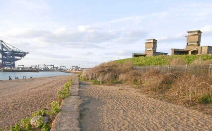
Coastal erosion is posing significant challenges for the seafront community at Hemsby and further north at the Winterton-Horsey Dunes National Nature Reserve. Concrete blocks, originally placed in the dunes during World War II to prevent the advance of invading tanks, now lie scattered along the beach, as the sand dunes underneath them have been washed away over the years.
The King Charles III England Coast Path is open all the way from Winterton-on-Sea to Weybourne and between Hunstanton and Sutton Bridge. Work is underway to compete the last remaining section in Norfolk, from Weybourne to Hunstanton.
The section of the coast is beautiful with long sandy beaches. There’s history to explore, 800,000 year old flint tools have been found here and the famous West Runton Elephant Fossil. Or you can enjoy the villages, walks, and of course try Cromer crab.
The sandy beaches at Hunstanton, Heacham and Shepherd’s Port present walkers with a seaside holiday vibe, also offering stunning sunsets and views across The Wash to Lincolnshire. But within these tourist honeypots sits a highly protected landscape, with multiple designations for wildlife. Local initiatives have made important progress in protecting the vulnerable species such as the ringed plover and oystercatcher which nest along the beaches.
Between Heacham and Snettisham, the path passes Wild Ken Hill estate, known for rewilding, regenerative farming, and traditional conservation practices – also a popular location for BBC’s Springwatch.
As a ‘superhighway’ for migratory birds during autumn and winter, an appealing part of the route is RSPB Snettisham reserve, where visitors can see the ‘whirling wader spectacular’. Having gathered to feed on the mudflats, species such as knot, dunlin and oystercatchers fly up into the air en masse with the rising tide and perform incredible murmurations.
Up to 40,000 pink-footed geese also gather in The Wash over winter, taking flight at first light in close V-shaped formations across the sky. They make an unmissable, high-pitched ‘wink-wink’ sound as they call to each other before they head inland to find food for the day.
The shoreline on the open coast between Snettisham and Sutton Bridge is predominantly alongside sea banks that were constructed to protect the drained arable farmland. The banks and adjacent saltmarsh are also grazed by cattle.
There is a sense of remoteness by the sea banks, with no public facilities or connecting paths for a number of miles, but with good services and transport links in the centres of King’s Lynn and Sutton Bridge. Between these two hubs, the path follows the Peter Scott Walk along the sea bank between West Lynn and the lighthouse on the mouth of the river Nene, which was once owned by Sir Peter Scott.
Although remote in parts, it is the perfect place to experience the splendid isolation of you and the thousands of other species, big and small, that live within the landscape.
Discover something new to explore every step of the way, from natural icons and historic attractions to coastal towns and villages…
View short walks on the trail's interactive map or browse the list by clicking the button below.

The listing you have clicked on is located on or close to more than one trail. Please select the trail you are interested in below to view the listing.
%buttons%