King Charles III England Coast Path – North East and East Coast – draft
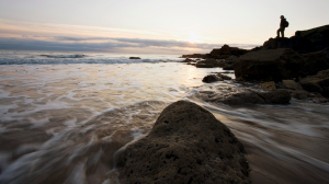
From the Wash to the Scottish Border this incredibly varied stretch of coast has everything from dramatic castles, charming fishing villages to long sandy beaches and lively seaside resorts.
The coastline of the North East of England truly has something for everyone. The Lincolnshire coast includes tidal marshes perfect for bird watching, beautiful beaches and lively seaside towns including Cleethorpes and Skegness. The coast of the East Riding of Yorkshire includes the famous seabird colonies of Bempton, the chalk cliffs of Flamborough Head and the fascinating Spurn Point. The North Yorkshire section offers iconic fishing villages clustered around tiny coves, stunning cliffs and popular coastal towns including Whitby and Scarborough. Further north, the Durham Heritage Coast section takes you through the mining villages of the Durham coast, where the coastal vegetation has been restored to wildlife-rich wildflower meadows. The Northumberland coast is famous for its long sandy beaches and dramatic coastal castles.
Lincolnshire
East Riding of Yorkshire
Middlesbrough, Redcar and the North Yorkshire coast
Durham, Hartlepool and Sunderland
Tyne and Wear
Northumberland Coast
Lincolnshire
The King Charles III England Coast Path in Lincolnshire is open from Sutton Bridge (the border with Norfolk) to Mablethorpe. Work is underway to complete the remaining parts of the trail in Lincolnshire.
Between Sutton Bridge and Skegness a section of the trail is closed due to an unsafe bridge. This section is currently not available for public use and no public access rights exist within this area. It is not possible to cross the River Steeping as the current private bridge is not safe for the public and a new bridge is being constructed.
The land owner at Friskney Eaudyke has given temporary permission for the public to use the track at this location to either access the coast from the village itself or to allow users that have travelled north the option to turn inland and return south on the public right of way network. Please respect the local residential properties and historic features that are closed to the public.
The section from Sutton bridge provides access to the shores of the Wash, one of the largest natural bays in England. Fed by several narrow navigable rivers on a modern coastline, the historic ports and associated settlements are some distance upstream. This also means the first bridging point is some distance upstream and users will find themselves following the canalised banks inland and back out to the open coast. As the coastline is relatively young there are few settlements and facilities along much of the stretch. An open and exposed, and sometimes harsh coastline. Ideal for birdlife, which is one of the key features of this landscape. Also ideal for MoD live firing ranges and users should be aware that military activities may be underway. These operations do not close the trail to users.
The trail restarts at Gibraltar Point, with its visitor centre, tea room and facilities that showcase the important wildlife of this geological phenomenon and the classic seaside town of Skegness and on to Mablethorpe, offering views across sands and out into the North Sea.
At Chapel St Leonards a new boardwalk links two promenades by the purpose-built North Sea Observatory at Chapel Point, improving accessibility for all. Open all year round, the Observatory is a great place to find out more about coastal wildlife, offering facilities such as exhibitions, art space and a café.
North Sea Observatory – photo by Lincolnshire County Council
The flat landscape shaped by the Ice Ages has an amazing ‘sea and skyscape’. Winter is often the best time of year with more clouds and large flocks of birds flying over the land and sea. Did you know the world’s first official cloud spotting area is at Anderby Creek Cloud Bar in the Coastal Country Park?
Wildlife thrives on the wilder areas of coast like Anderby Creek in the Lincolnshire Coastal Country Park. Dunes shaped by the wind and sea are home to special plants, birds and insects and a great backdrop for bracing walks. In winter the beaches are home to large flocks of winter waders such as sanderling and oystercatcher. In spring flocks of pink-footed geese move along the coast and flocks of golden plover and lapwing can be spotted on adjacent farmland.
A submerged forest (Site of Special Scientific Interest) dating from the Neolithic Period (4 – 6,000 years ago) is occasionally visible at very low tides at Chapel Six Marshes and Wolla Bank.
The big skies and special qualities of the Lincolnshire coast have inspired creative art and architecture. Take a peek at some 21stcentury beach huts or ‘bathing beauties’.
East Riding of Yorkshire
The East Riding of Yorkshire section of the King Charles III England Coast Path is open from the border with North Yorkshire south of Filey, around Flamborough Head and to Bridlington. There is then a gap as you head south, the next section to be open is from Easington (near Spurn Point) to the Humber Bridge. Work is ongoing on the remaining sections between Filey and Easington.
Humber Bridge – Photo by Different Resonance on Unsplash
The route passes through popular coastal chalk scenery and the UK’s largest seabird colony which can be viewed from the cliff tops at RSPB Bempton. Here puffins, gannets, kittiwakes and guillemots can be seen when nesting. From Bempton the trail takes you on to the world famous Flamborough Head, with its impressive high stacks and cliffs, the most northerly chalk cliffs in the UK. Visitors can wind around its many coves and bays used by smugglers in the 18th century, before arriving at the two lighthouses of Flamborough, the old lighthouse from 1674 and the new 1806 lighthouse, both of which are Grade II listed buildings.
From Flamborough it is a short stroll to Bridlington with its fabulous beach and tourist attractions.
The next open section start at Easington. This 40 miles (65km) stretch of the King Charles III Coast Path includes a remarkable contrast in landscapes. From its upstream extent the route crosses the Humber Bridge – one of the most iconic man-made structures in northern England.
It then follows the estuary downstream, past both atmospheric disused and then busy docks and then on into the historic area of the Hull Marina. Passing the vibrant Market Street area the trail crosses the River Hull with its tidal surge barrier and past the celebration of sea life, The Deep.
Further down the estuary, past the Saltend Chemical works the nature of the trail changes completely. Here the waters of the Humber Estuary contribute to a landscape that is always changing due to the tidal movements, exposing extensive mudflats at low tide, and the effects of the changing weather. Large ships, including ferries, container ships and cargo ships, are constantly moving in and out of the estuary.
The trail now follows the flood banks, giving easy level walking, enormous skies and distant views. Towards the mouth of the estuary the lighthouses at Spurn Point come into view – an amazing place well worth exploring and giving fantastic bird watching and wildlife photography opportunities before the stretch ends on the edge of the small village of Easington.
Middlesbrough, Redcar and the North Yorkshire coast
This section of the King Charles III England Coast Path from Middlesbrough through the North Yorkshire Coast is fully open to the border with the East Riding of Yorkshire just to the north of Bridlington.
This section takes you along the dramatic cliffs of the North Yorkshire coast from the industrial heart of Middlesbrough through the coastal towns of Redcar, Saltburn, Whitby, Scarborough and Filey. The trail connects the communities of Teesside with their beautiful open coast, with its beaches, small fishing villages and remote cliff tops. With stunning views, peaceful sections where you may only have the sea birds for company to the bustling tourist destinations, it’s a coast of contrasts.
Make time to visit Saltburn’s historic cliff lift, Saltburn’s pier – the only one left in Yorkshire, eat fish and chips in Whitby and take a boat ride around the harbour, walk along Filey Brigg and soak up the history of this special section of coast.
Part of this stretch comprises the coastal part of the existing Cleveland Way National Trail. The main advantage for the coastal sections of this existing National Trail becoming part of the King Charles III England Coast Path is the ability of the path to adapt to coastal erosion via “rollback”. This is new legislation, associated with the King Charles III England Coast Path, ensures that the path will be available for walkers in perpetuity – a major plus for this spectacular, but crumbling coast.
You will find the path is waymarked as the Cleveland Way, and also the King Charles III England Coast Path.
Durham, Hartlepool and Sunderland
The Durham, Hartlepool and Sunderland section follows the Durham Heritage Coast and is fully open.
This coast was devastated by the mining industry throughout the 20th century. The closure of the mines in the early 1990s changed the area dramatically, resulting in high levels of unemployment and poverty. However the reduction in industry has had a positive impact on the coast which has been restored through the Turning the Tide Project and now is a rich natural and cultural asset, important to the region’s economy and well being.
The scenery and wildlife make this coast special. The area is famous for its wildflowers. If you’re looking to explore the section in the North East make sure you don’t miss out on the retro Lickety Split Creamery in Seaham for the best ever ice cream sundaes!
Durham Heritage Coast
It’s not all flowers and ice cream though. Hartlepool has always been an important maritime town and still is to this day. Tourists can enjoy the new marina, the Hartlepool’s Maritime Experience, and heritage trails around the town.
Sunderland’s history is tied to the sea and ship building. Today the city is popular for shopping and is home to the fascinating National Glass Centre as well as many other attractions, including the Stadium of Light, home of Sunderland AFC.
Tyne and Wear
The King Charles III England Coast Path is fully open through Tyne and Wear.
This section is full of unexpected delights, including a Roman fort, dramatic lighthouses, nature reserves and stunning beaches. Many of the locations feature regularly in the TV detective series ‘Vera’, including Whitley Bay and St Mary’s Island.
For stunning views of the local nature reserve visit Souter Lighthouse in South Tyneside. The lighthouse is owned and managed by the National Trust and sits on a grassy cliff of rare magnesian limestone. Built in 1871, it was the first in the world to run on electricity.
Souter Lighthouse – National Trust
Arbeia Roman Fort at South Shields was a key garrison and military supply base to other forts along the Wall and is an important part of the history of Roman Britain. Standing above the entrance to the River Tyne, Arbeia South Shields’ Roman Fort guarded the main sea route to Hadrian’s Wall. Stories are brought to life at Arbeia through a variety of events and displays including gladiator battles, falconry displays, Roman re-enactments, storytelling and more.
Shields Ferry – crosses the Tyne and links up South Shields to North Shields.
Overlooking the North Sea and the River Tyne, Tynemouth Castle and Priory dominates the headland. It was once one of the largest fortified areas in England and with its 2000 year history and beautiful views it is the perfect location for a family fun day out. A popular spot to enjoy seaside fish and chips with a view and great location to have a picnic, lie back and enjoy the sea air.
For spectacular views climb the 137 steps to the top of St Mary’s Lighthouse at Whitley Bay. An exhibition explains the history of the Lighthouse and give an insight into the wildlife of St. Mary’s Nature Reserve. The lighthouse is reached between the tides via a short causeway.
After all that you’ll be in need of refreshment! Enjoy fish and chips or afternoon tea at Spanish City on the sea front in Whitley Bay.
Northumberland Coast
From Seaton Sluice in Tyneside to the Scottish Border just to the north of Berwick upon Tweed the King Charles III England Coast Path is fully open in Northumberland.
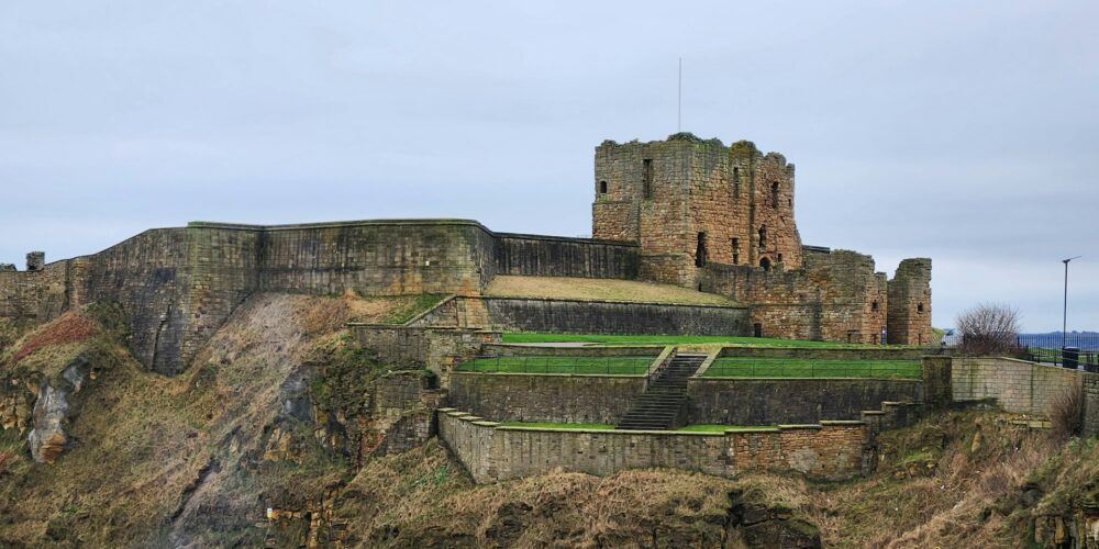
Known for its wild sandy beaches and rolling dunes, along with the wide open inter-tidal mudflats seen at low tide, the coastline and its shores support an abundance of wildlife from wildflowers and seabirds to seals and dolphins. Famed for its castles, ruins, and abbeys, each with their own story to tell – from towering ramparts to haunting ruins, these magnificent buildings echo with the history of the kings, monks and Vikings who lived and fought here. The trail leads to Holy Island Priory and connects to the lovely village of Bamburgh where Bamburgh Castle, the seat of the early Kings of Northumbria, sits high above the village green on one side and the beach on the other, dominating the skyline.
Dotted with historic towns too, the spectacular coastline boasts rocky islands and pretty harbour villages where fisherman have landed their catches for generations. Beautiful beaches, the North Sea’s clean, clear waters and big skies make it an ideal destination for anyone wanting to get their feet wet, get away from it all or seek out natural and historical wonders. Thoughtfully designed, the path respects sensitive, historic sites and the natural environment so that future generations can enjoy the area’s beauty while preserving its heritage.
History, heritage and hidden gems
Discover something new to explore every step of the way, from natural icons and historic attractions to coastal towns and villages…
Home » The Trails » King Charles III England Coast Path – North East and East Coast – draft
Attention please!
The listing you have clicked on is located on or close to more than one trail. Please select the trail you are interested in below to view the listing.
%buttons%
Manage Cookie Consent
We use cookies to optimize our website and our service.
Functional cookies
Always active
The technical storage or access is strictly necessary for the legitimate purpose of enabling the use of a specific service explicitly requested by the subscriber or user, or for the sole purpose of carrying out the transmission of a communication over an electronic communications network.
Preferences
The technical storage or access is necessary for the legitimate purpose of storing preferences that are not requested by the subscriber or user.
Statistics
The technical storage or access that is used exclusively for statistical purposes.The technical storage or access that is used exclusively for anonymous statistical purposes. Without a subpoena, voluntary compliance on the part of your Internet Service Provider, or additional records from a third party, information stored or retrieved for this purpose alone cannot usually be used to identify you.
Marketing
The technical storage or access is required to create user profiles to send advertising, or to track the user on a website or across several websites for similar marketing purposes.